
Located in the Swiss cantons of Vaud and Fribourg, stretching from the Vaud riviera (Montreux) to Bulle, from Gstaad to Gruyères, the Gruyère Pays d'Enhaut Regional Natural Park is an unspoiled rural area in the foothills of the Alps but has also been a popular tourist destination since the 19th century.
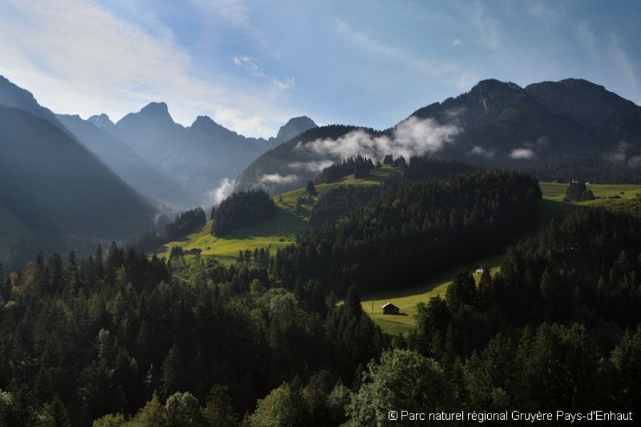
Most of the park lies between 800m and 2,000m above sea level. It is home to a patchwork of villages, hamlets, meadows, summer grazing, mountainous areas and woodland. The park boasts a wealth of different landscapes, wildlife and plant life. Outstanding biotopes and geotopes bear witness to the unspoiled nature of the zones that are so vital for a rich variety of flora and fauna, including the Vanil Noir, Pierreuse, and Étivaz valley reserves, all of which are managed by the Pro Natura organisation.
Dairy farming is the mainstay of agriculture with around 230 farms in the area (over 26 million kilos per annum). There are three registered cheeses: L'Étivaz AOC, Gruyère AOC and Vacherin Fribourgeois AOC. The regional economy is built around tourism (ski resorts, sports and leisure, hotels and second homes) with a variety of focal points in the area.
The Parc naturel régional Gruyère Pays-d’Enhaut association was formed in February 2006 with the aim of creating and managing a regional natural park. The organisation had two founding principles: compliance with the federal decree requiring local authorities to have decision-making powers and a commitment to involving local stakeholders. Thus the local authorities have more to contribute in terms of coordination and replication whilst the agricultural, tourism and business sectors will be involved in practical actions and projects.
In order to qualify for the "park of national importance" label, the project will be officially registered in January 2011 when the charter setting out the size and geographic area of the Park, its financing, activities and objectives is lodged. The charter comprises three documents: the Park contract (setting out the financial and strategic links between the local authorities and the association: boundaries, organisational structure and mandate, local authority funding), a description of the Park area and the management plan for the operational phase (the ten-year period covered by the park label, effective from 2011), which combines a ten-year plan and a four-year action plan.
Gruyère Pays-d’Enhaut Regional Natural Park
Place du Village 6
CH – 1660 Château-d’Œx
Tel. +41 26 924 76 93
Fax. +41 26 924 79 97
info@pnr-gp.ch
Park's identity card
|
Name of protected area |
|
|
Managing body (if different) |
- |
|
Country |
Switzerland |
|
Area (ha) |
50 246 |
|
Year of creation |
2011 |
|
UICN category |
- |
|
Legal basis |
Proposal for regional natural park (park of national importance) |
|
Regions covered |
Fribourg canton (Jogne and Intyamon valleys), Vaud canton (Pays d'Enhaut, Rochers de Naye). |
|
Number of municipalities |
14 |
|
Highest point (m) |
2 548 |
|
Lowest point (m) |
372 |
|
Population |
12,585 inhabitants (2009) |
|
Forested land |
c. 20,000 ha |
|
Glacier |
0 ha |
|
Pasture land |
c. 17,000 ha |
|
Prevailing landscapes |
Landscapes typical of Alpine foothills made up largely of woodland, meadows, grazing, cliffs and scree. Combination of villages, hamlets and summer grazing land. |
|
Emblematic fauna |
Ibex, chamois, marmot, three-toed woodpecker, rock ptarmigan, black grouse and whinchat. |
|
Emblematic flora |
Narcissus radiiflorus, willow gentian, Alpine columbine, St Bruno's lily |
|
Major tourist attractions |
Château de Chillon, Le Grand Chalet de Rossinière (home of the painter Balthus), demonstrations of cheese-making (Col de Jaman, Maison de l'Etivaz), nature reserves (Vanil Noir, La Pierreuse, Vallée de l’Etivaz) |
|
Information centre(s) (quantity, name, topics) |
First information centre to be opened in spring 2011. Other visitor centres are planned and will be set up at key locations in the park. |
|
Website |
|
|
Number of employees |
6 plus interns |
|
Getting there |
From Bulle: TPF train (towards Montbovon) and Charmey bus. |


